
Complete Catalog
The catalog contains 1606 items. This is our complete list of books.
| Image |
Description Subject, Author, Title, Bibliography |
Price EUR |
|
|---|---|---|---|
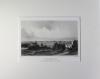 |
Braunschweig: Gesamtansicht: Poppel- Braunschweig von Richmond aus. Stahlstich von Poppel nach Tacke, 1858 bei Gustav Lange in Darmstadt erschienen. 11 x 17 cm. Gut erhalten, das Blatt wurde gereinigt. | 75,-- |  |
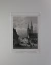 |
Braunschweig: Katharinenkirche: Katharinenkirche in Braunschweig. Stahlstich von Oeder nach Rohbock, 1858 bei G. Lange in Darmstadt erschienen. 14,6 x 11,1 cm. Gut erhalten. | 85,-- | |
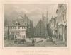 |
Braunschweig: Kohlmarkt: Der Kohlmarkt in Braunschweig. Stahlstich von Kolb nach Rohbock, 1858 bei G. Lange in Darmstadt erschienen. 11,2 x 16 cm. Passepartout: 26 x 35 cm. Unten am Rand wenig stockfleckig, sonst gut erhalten. | 60,-- | |
 |
Braunschweig: Martinkirche: Braunschweig die Martinikirche. Stahlstich von Kurz nach Emil Schulz, 1858. 10,5 x 16 cm. Etwas stockfleckig, sonst gut erhalten. | 60,-- | |
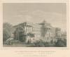 |
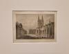
Braunschweig: Residenzschloss: Das Residenzschloss zu Braunschweig. Stahlstich von Kolb nach Rohbock, 1858 bei G. Lange in Darmstadt erschienen. 11,1 x 15,9 cm. Am Rand wenig stockfleckig, sonst gut erhalten. | 60,-- | |
 |
Braunschweig: Schloss Richmond: Altes Schloss zu Richmond. Stahlstich von Kurz nach Rohbock, 1858 bei G. Lange in Darmstadt erschienen. 11,1 x 15,8 cm. Oben knapprandig, sonst gut erhalten. | 60,-- | |
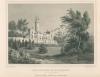 |
Braunschweig: Schloss Richmond: Das Schloss zu Richmond. Stahlstich von Poppel nach Rohbock, 1858 bei G. Lange in Darmstadt erschienen. 11 x 15,9 cm. Am etwas stockfleckig, sonst gut erhalten. | 40,-- | |
 |
Bregenz: Bodensee: Bregenz am Bodensee. Stahlstich von Richter nach Corradis, 1853. (Auf Chinapapier) 11 x 15,5 cm. Gut erhalten. | 40,-- | |
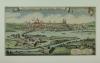 |
Breisach: Merian: Wahre Contrafactur Der Vesten Statt und Passes Brysach. Kupferstich von Merian, koloriert, 1645. 19 x 35 cm. Dem Alter entsprechend gut erhalten. | 180,-- | |
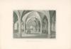 |
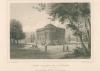
Bremen: Die Künstler-Halle. Stahlstich von Kurz nach Gottheil, um 1885. 12,5 x 18.7 cm. Gut erhalten. | 25,-- | |
|
Entries 591–600 of 1606
|
|||
HescomShop - Das Webshopsystem für Antiquariate und Verlage | © 2006-2026 by HESCOM-Software. Alle Rechte vorbehalten.