
Maps
Die Liste enthält 144 Einträge. Suchergebnisse löschen und Gesamtbestand anzeigen.
| Abbildung |
Beschreibung Stichwort, Autor, Titel, Buchbeschreibung |
Preis EUR |
|
|---|---|---|---|
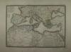 |
Europa: Nordafrika: Mittelmeeranrainerstaaten: CARTE GENERALE DES ETATS DU NORD DE L´AFRIQUE, de la MER MEDITERRANÉE et DE L´EUROPE MERIDIONALE. Grenzkolorierter Stahlstich nach Adrian-Hubert Brué bei Barthelemier in Paris, 1858. 36 x 50,7 cm. 52 x 70 cm. Einige Stockflecken, sonst gut erhalten. | 180,-- |  |
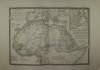 |
Nordafrika: Kaiserreich Abessinien: CARTE DÉTAILLÉE en deux feuilles DE L´AFRIQUE et des ILLES QUI EN DEPENDENT Grenzkolorierter Stahlstich nach Adrian-Hubert Brué bei Barthelemier in Paris, 1858. 36 x 50,5 cm Karte. 52 x 70 cm Blatt. Gut erhalten. | 100,-- | |
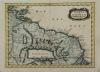 |
Amazonas Mündung: Suriname: Guyana: Golf von Paria: GUIANA in GUIANAM & CARIBANAM divisa. Kolorierter Kupferstich, Nicolas Sanson um 1690. 20 x 27 cm. Rechts am Rand ein 2,5 cm kleiner Einriß, hinterlegt mit reparaturband. Insgesamt gut erhalten. | 75,-- | |
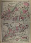 |
Canada: Johnson´s Lower Canada and New Brunswick – Upper Canada. Kolorierte Lithografie bei Johnson und Ward in New York erschienen. Coloured lithograph published by Johnson and Ward in New York, 1864. Bildformat: 61 x 40 cm. Gut erhalten. | 140,-- | |
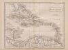 |
Karibik: West Indies: West Indies. Kupferstich von Hall, aus Samuel Butlers „Atlas of modern geography“, 1836. 18,2 x 23,7 cm. Gut erhalten. | 50,-- | |
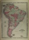 |
Südamerika: South America: Johnsons South America. Kolorierte Lithografie bei Johnson und Ward in New York erschienen. Coloured lithograph published by Johnson and Ward in New York, 1864. Bildformat: 56,5 x 40,5 cm. Blattformat: 67 x 40,5 cm. Gut erhalten. | 200,-- | |
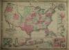 |
USA: Map: Military: Johnson´s New Military Map of the United States. Showing the Forts, Military Posts & c. with … Kolorierte Lithografie bei Johnson und Ward in New York erschienen. Coloured lithograph published by Johnson and Ward in New York, 1864. 44 x 60,5 cm inkl Bordüre. Gut erhalten. | 220,-- | |
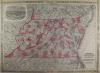 |
USA: Maryland: Delaware: Maryland: Johnson´s Virginia Delaware and Maryland. Kolorierte Lithografie bei Johnson und Ward in New York erschienen. Coloured lithograph published by Johnson and Ward in New York, 1864. 44,5 x 61 cm inkl. Bordüre. Gut erhalten. | 180,-- | |
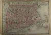 |
USA: Massachusetts Connecticut: Rhode Island: Johnsons Massachusetts Connecticut and Rhode Island. Kolorierte Lithografie bei Johnson und Ward in New York erschienen. Coloured lithograph published by Johnson and Ward in New York, 1864. 44 x 61 cm. Blattformat: 46 x 67 cm. Gut erhalten. | 180,-- | |
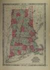 |
USA: Vermont: New Hampshire: Rhode Island: Johnsons Vermont, New Hampshire, Massachusetts, Rhode Island, and Connecticut. Kolorierte Lithografie bei Johnson und Ward in New York erschienen. Coloured lithograph published by Johnson and Ward in New York, 1864. 37 x 54 cm. Blattformat: 45,5 x 67 cm. Zwei hinterlegte Einrisse. Sonst gut erhalten. | 200,-- | |
|
Einträge 101–110 von 144
|
|||
Sortiert nach: Autor · Titel · Katalogsortierung · Erscheinungsjahr · Preis · Letzte Änderung · Relevanz
HescomShop - Das Webshopsystem für Antiquariate und Verlage | © 2006-2026 by HESCOM-Software. Alle Rechte vorbehalten.