
Landkarten
Die Liste enthält 199 Einträge. Suchergebnisse löschen und Gesamtbestand anzeigen.
| Abbildung |
Beschreibung Stichwort, Autor, Titel, Buchbeschreibung |
Preis EUR |
|
|---|---|---|---|
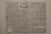 |
Trient: Fürstentum: Territorium Tridentinum. Kupferstich bei Janssonius- Waesberge erschienen, um 1680. 37 x 48 cm. Blattformat: 51 x 65 cm. Gut erhalten. | 184,-- |  |
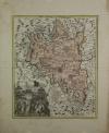 |
Tschechien: Cheb: Eger: Egerland: Böhmen: „Districtus Egranus per L. C. Mullerum excusus a Weigelio …“ kolorierter Kupferstich nach Müller bei J.C. Weigel in Nürnberg, ca. 1720. 38 x 31,5cm. Oben ausserhalb der Karte Wasserrandig, links einige Stockflecken, unten kleiner Einriß hinterlegt. | 160,-- | |
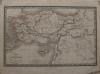 |
Türkei: Anatolien: Syrien: Carte de L´Asie Mineure et des Contrées. Stahlstich nach Reichard, um 1860. 26 x 40,5 cm. Einige Flecken, sonst gut erhalten. | 24,-- | |
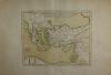 |
Türkei: Syrien: Griechenland: Delisle. Tabula Geographica Provinciarum et Urbium. Kupferstich von Guillaume Delisle bei Phillipe Buache, 1745 datiert, erschienen 1776. 33,5 x 41,5 cm, gut erhalten. | 160,-- | |
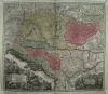 |
Ungarn: Südosteuropa: Seutter. Novißima et accuratißima Hungariae cum circumjacentibus Regnis et Principatibus in mappa Geographica Designatio … Altkolorierter Kupferstich von Matthäus Seutter, nach 1741. 50 x 58 cm, gut erhalten. Deutscher Kunstverlag „Die Welt aus Augsburg“ | 400,-- | |
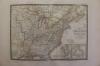 |
USA: America: Carte Generale des Etats-Unis, des Haut et Bas-Canada. Grenzkolorierter Stahlstich nach Adrian-Hubert Brué bei Barthelemier in Paris, 1858. 36 x 50,5 cm. Blattformat: 52, x 70 cm. Wenige Stockflecken am Rand des Blattes, sonst gut erhalten. | 160,-- | |
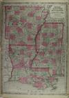 |
USA: Arkansas: Mississippi: Louisiana: Johnsons Arkansas, Mississippi and Louisiana. Kolorierte Lithografie bei Johnson und Ward in New York erschienen. Coloured lithograph published by Johnson and Ward in New York, 1864. Blattformat: 67 x 46 cm. Wenige Stockflecken, sonst gut erhalten. | 80,-- | |
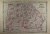 |
USA: Georgia: Alabama: Johnsons Georgia and Alabama. Kolorierte Lithografie bei Johnson und Ward in New York erschienen. Coloured lithograph published by Johnson and Ward in New York, 1864. 39,5 x 55,5 cm. 46 x 67 cm. Wenige Flecken, sonst prima erhalten. | 120,-- | |
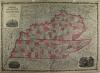 |
USA: Kentucky: Tennessee: Johnson´s Kentucky and Tennessee. Kolorierte Lithografie bei Johnson und Ward in New York erschienen. Coloured lithograph published by Johnson and Ward in New York, 1864. 43 x 61 cm inkl. Bordüre. Gut erhalten. | 144,-- | |
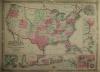 |
USA: Map: Military: Johnson´s New Military Map of the United States. Showing the Forts, Military Posts & c. with … Kolorierte Lithografie bei Johnson und Ward in New York erschienen. Coloured lithograph published by Johnson and Ward in New York, 1864. 44 x 60,5 cm inkl Bordüre. Gut erhalten. | 176,-- | |
 |
USA: Maryland: Delaware: Maryland: Johnson´s Virginia Delaware and Maryland. Kolorierte Lithografie bei Johnson und Ward in New York erschienen. Coloured lithograph published by Johnson and Ward in New York, 1864. 44,5 x 61 cm inkl. Bordüre. Gut erhalten. | 144,-- | |
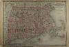 |
USA: Massachusetts Connecticut: Rhode Island: Johnsons Massachusetts Connecticut and Rhode Island. Kolorierte Lithografie bei Johnson und Ward in New York erschienen. Coloured lithograph published by Johnson and Ward in New York, 1864. 44 x 61 cm. Blattformat: 46 x 67 cm. Gut erhalten. | 144,-- | |
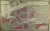 |
USA: New York: Johnsons Map of New York and the adjacent cities. Kolorierte Lithografie bei Johnson und Ward in New York erschienen. Coloured lithograph published by Johnson and Ward in New York, 1864. 41 x 66 cm. Blattformat: 45 x 67 cm. Prima erhalten. | 176,-- | |
 |
USA: New York: Johnson´s New York. Kolorierte Lithografie bei Johnson und Ward in New York erschienen. Coloured lithograph published by Johnson and Ward in New York, 1864. 42 x 63 cm mit Bordüre. Gut erhalten. | 176,-- | |
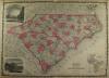 |
USA: North – South Carolina: Johnsons North and South Carolina. Kolorierte Lithografie bei Johnson und Ward in New York erschienen. Coloured lithograph published by Johnson and Ward in New York, 1864. 42,5 x 60 cm inkl. Bordüre. Gut erhalten. | 96,-- | |
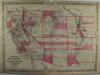 |
USA: Südwesten der Vereinigten Staaten: Southwest America: Johnsons California, with territories of Utha, Nevada, Colorado, New Mexico and Arizona. Kolorierte Lithografie bei Johnson und Ward in New York erschienen. Coloured lithograph published by Johnson and Ward in New York, 1864. 43 x 59,5 cm inkl. Bordüre. Unten 2 Flecken, links im Bild senkrechte Knickfalte, sonst gut erhalten. 2 stains at lower margin, vertical crease at left side of image, otherwise well preserved. | 176,-- | |
 |
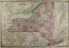
USA: Vermont: New Hampshire: Rhode Island: Johnsons Vermont, New Hampshire, Massachusetts, Rhode Island, and Connecticut. Kolorierte Lithografie bei Johnson und Ward in New York erschienen. Coloured lithograph published by Johnson and Ward in New York, 1864. 37 x 54 cm. Blattformat: 45,5 x 67 cm. Zwei hinterlegte Einrisse. Sonst gut erhalten. | 160,-- | |
 |
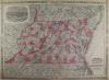
USA: Vicinity of Richmond: Peninsular Campaign in Virginia: Johnsons Map of The Vicinity of Richmond, Peninsular Campaign in Virginia. Kolorierte Lithografie bei Johnson und Ward in New York erschienen. Coloured lithograph published by Johnson and Ward in New York, 1864. 45 x 67 cm. Etwas knaprandig, sonst gut erhalten. | 144,-- | |
 |
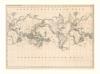
Weltkarte: MAPPEMONDE LA PROJECTION DE MERCATOR. Grenzkolorierter Stahlstich nach Adrian-Hubert Brué bei Barthelemier in Paris, 1858. 36,4 x 51 cm Ansicht. 52 x 70 cm Blatt. Am Rand etwas stockfleckig, sonst gut erhalten. | 224,-- | |
 |
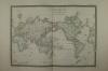
Weltkarte: ohne Titel. Lithografie nach K.F.V. Hoffmann, ca. 1840. 24 x 34,3 cm, Knickfalten da aus einem Buch. | 48,-- | |
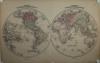 |
Weltkarte in zwei Hemisphären: Johnson´s Western Hemisphere – Eastern Hemisphere. Kolorierte Lithografie bei Johnson und Ward in New York erschienen. Coloured lithograph published by Johnson and Ward in New York, 1864. 34 x 67 cm. Die Mittelfalz wurde fachmännisch restauriert. Gut erhalten. | 200,-- | |
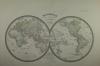 |
Weltkarte: 2 Hemisphären: MAPPEMONDE en deux Hemisphéres. Grenzkolorierter Stahlstich nach Adrian-Hubert Brué bei Barthelemier in Paris, 1858. 28 x 53 cm Ansicht. 52 x 70 cm Blatt. Gut erhalten. | 200,-- | |
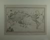 |
Weltkarte: World Map: Mappe Monde sur la Projection Réduite de Mercator. Grenzkolorierter Kupferstich von Chamouin nach Giraldon, um 1815. 28,5 x 44,5 cm. Breitrandig, gut erhalten. | 208,-- | |
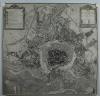 |
Wien: Kupferstich: Plan: Grundriss Der Residenzstadt Wien und der sämtlichen Vorstädte nach den neuesten Verbesserungen. Kupferstich von Ludewig Schmidt nach Josephi in Berlin, 1783. Copper engraving by Ludewig Schmidt after Josephi in Berlin, 1783. 41 x 43 cm, 42 x 44 cm. Das Blatt wurde an 2 Stellen fachmännisch restauriert. Knapprandig, insgesamt gut erhalten. The sheet was professionally restored in 2 places. Scarce margins, overall well preserved. | 376,-- | |
|
Einträge 176–199 von 199
Zurück · Vor
|
|||
Sortiert nach: Autor · Titel · Katalogsortierung · Erscheinungsjahr · Preis · Letzte Änderung · Relevanz
HescomShop - Das Webshopsystem für Antiquariate und Verlage | © 2006-2025 by HESCOM-Software. Alle Rechte vorbehalten.